Bengal’s great river confluence of sunsets, ferries and open horizons
Location Category
Location Circuits
Location Interest
Location How Many Days
Location Group
Location Content
Text Body
There are places in West Bengal that are easy to describe and places that resist description entirely. Gadiara belongs to the second category. Stand on the embankment at dusk as the sun drops toward the water and the lights of Haldia, Nurpur and Geonkhali begin to prick the far bank, the Hooghly widening below you until it is no longer clearly a river but something that rhymes with the sea and you will understand immediately why this confluence of the Hooghly, the Rupnarayan and the Damodar has been drawing Bengali city-dwellers south on weekends for as long as there have been city-dwellers in Kolkata to draw.
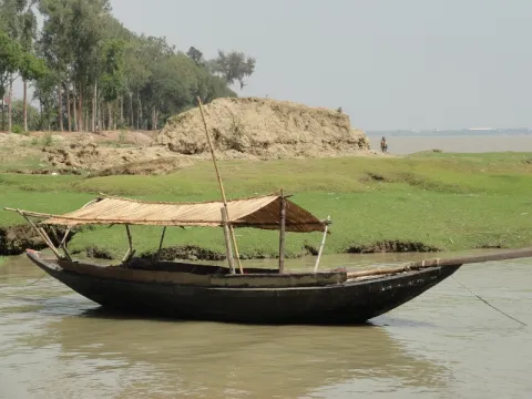
Gadiara sits at one of the great hydraulic junctions of the Gangetic delta, roughly 90-100km south of Kolkata, where the Rupnarayan and the Damodar surrender themselves to the Hooghly within sight of each other. The result is what locals call a ‘mini sea’: a horizon of water broad enough that cargo ships and fishing trawlers move across it with the unhurried authority of vessels that feel no urgency at this scale. Across the water, accessible by ferry, lies Nurpur, this guide's second geographical anchor and a useful gateway to Diamond Harbour, Haldia and the Mahishadal Rajbari palace beyond.
The area has history as well as scenery. Fort Mornington, built by Robert Clive after Plassey in 1757 and now half-dissolved into the river it was built to command, is one of the more quietly extraordinary colonial ruins in Bengal. The Rupnarayan riverbank stretching north toward Kolaghat, characterized by mustard fields in winter, paddy in the monsoon and punctuated by country boats at every landing, was also home for twelve years to Sarat Chandra Chattopadhyay, one of the greatest novelists Bengal has produced; his house at Samta is covered in the companion guide to Deulti-Samta.
This is, in the best possible sense, a destination for those who know how to be idle. The true essence of the Gadiara experience is sitting at the confluence and watching the water: the three rivers becoming one, the cargo ships crossing the far channel, the light changing on a surface too wide to read all at once. Everything else, the historic fort, the ferry crossing, the fish dinners, the sunsets, is an enjoyable addition to that central, irreplaceable thing.
History
The Rivers and Their Long Story
Long before any fort was built here, the confluence of the Hooghly, Rupnarayan and Damodar was a place of consequence. The Rupnarayan, which flows down from the Chhota Nagpur plateau as the Dhaleswari (Dhalkisor), passing through Bankura district as the Dwarakeswar and assuming the name Rupnarayan as it approaches the coastal plain, has been a conduit for trade between the forested highlands of Jharkhand and Odisha and the delta ports of Bengal for millennia. Salt, iron, terracotta, forest produce and cloth all moved along this corridor. Rising in the Hazaribagh plateau, the Damodar River transported the bounty of its distinct watershed: the coal that would ultimately power Bengal's industrial revolution under the British and the agricultural richness of the Burdwan plain.
The confluence itself, where these highland rivers met the tidal force of the Hooghly, a distributary of the Ganges that the Mughals and the British alike regarded as the master commercial artery of eastern India, was a natural checkpoint for river traffic. Pilots, traders and port officials were drawn to it. The Mughal administration monitored river tolls here. And in the early years of the British East India Company’s presence in Bengal, the confluence acquired strategic military significance as the point at which vessels ascending the Hooghly from the Bay of Bengal would first enter the inland river network.
Fort Mornington and the Age of Clive
The great transformation of Gadiara’s history came in 1757. On 23 June of that year, Robert Clive, commanding a force of roughly 3,000 men, comprising a mix of European troops, Indian sepoys and artillery, defeated the numerically vastly superior army of Siraj-ud-Daulah, the last independent Nawab of Bengal, at the Battle of Plassey on the banks of the Bhagirathi. The battle lasted barely eleven hours. The result was the effective beginning of British rule in India: it transformed the East India Company from a trading power into a political one. Clive soon became governor of Bengal and in 1765 the Company secured the right to collect Bengal’s revenues.
The strategic imperatives of this new power required the fortification of key river positions. The confluence at Gadiara, the point where any hostile fleet ascending from the sea would need to navigate the split between the Hooghly, the Rupnarayan and the Damodar, was an obvious site for a defensive position. While the initial mandate to secure the river is often attributed to Clive in the immediate aftermath of Plassey, the fortification that eventually commanded the waters was Fort Mornington, constructed and named decades later during the tenure of Richard Wellesley, Earl of Mornington. Nevertheless, the imposing shadow of Plassey's victor easily eclipsed the actual chronology of the bricks; the site was colloquially dubbed Clive’s Fort and this is the name by which most visitors know it today.
The fort guarded the confluence for the better part of two centuries, monitoring and if necessary interdicting river traffic from the east and south. As British power in Bengal became uncontested and the threat of rival European powers or Nawabi forces faded, the strategic rationale for Fort Mornington diminished. By the early 20th century the fort had been largely abandoned. Then in 1942, severe flooding struck a decisive blow: a large portion of the structure was destroyed. All that survives today are low, ruined walls and foundations, many of which are only visible when the tide is out. This is a quietly extraordinary sight: the fort, which was built to control the river, has now been partially dissolved by it.
The Howrah District: Manchester of Bengal
Gadiara and Nurpur belong to Howrah district, which has one of the most distinctive economic and cultural identities in West Bengal. The northern part of the district, the city of Howrah itself, across the Hooghly from Kolkata, was the industrial powerhouse of British India from the mid-19th century onward: jute mills, engineering works, cotton factories and the iron-frame of Howrah Bridge (completed 1943) made ‘Howrah’ synonymous in the colonial imagination with the industrial sinew of Bengal. The southern part of the district, the rural hinterland along the Rupnarayan, the low-lying flood plains between the Hooghly and the Damodar, the estuarine fringes approaching the Bay of Bengal, is a different world entirely: agricultural, tidal, quiet, unhurried.
Gadiara belongs to this southern quiet. Its history is shaped less by industrialisation than by the rhythms of the rivers: the annual floods that determined crop cycles and village boundaries, the passage of cargo boats and fishing vessels, the colonial-era trade that brought salt and indigo down from the north and exported rice and jute south to the ports. The 1942 floods that damaged Fort Mornington were part of a longer history of the rivers asserting their authority over the human structures built on their banks.
Title
History and Culture
Is Background Visible
Off
Location Information Items
Section Title
Top Sights and Experiences
Text Body
Getting There
By Train: The most scenic way to Gadiara is by South Eastern Railway EMU from Howrah Junction to Bagnan (1-1.5 hours). From Bagnan station, take a bus or shared van to Shyampur (approx. 25km, 30-45 mins). Finally, hire an auto-rickshaw for the picturesque 8km ride to the Gadiara embankment (agree on fare beforehand). The total journey from Howrah takes 2.5-3 hours.
By Direct Bus: CSTC (state-owned) and private buses go directly from Kolkata's Dalhousie/Esplanade (near KC Das sweet shop) to Gadiara. The journey takes about 2.5-3 hours. Alternatively, buses run from Esplanade (Kolkata) to Nurpur, from where ferries cross to Gadiara in minutes. This route is convenient for those near or arriving from Haldia/the south.
By Ferry from Nurpur: A regular ferry service connects Nurpur and Gadiara. Visitors from Haldia, Diamond Harbour, or the Hooghly's eastern bank can take this practical and scenic 15-20 minute crossing from Nurpur, enjoying excellent river views of the confluence upon arrival.
By Road: Driving from Kolkata, the standard route is west on National Highway 16 (formerly NH 6) through Panchla and Uluberia, then south to Gadiara via Shyampur. The trip is about 90-100km and takes 2-2.5 hours, depending on traffic near Uluberia and the narrow rural roads in the Shyampur block, which may be slow due to agricultural vehicles.
Getting Around
Gadiara is a compact settlement easily explored on foot. The embankment, Fort Mornington ruins, lighthouse, tourist lodge and nearby stalls/guesthouses are all close to the bus stop. Simple village walks into the paddy fields are also possible. For excursions to Garchumuk (Hooghly-Damodar confluence, barrage, deer park) and Panitras-Samtaber (Sarat Chandra Kuthi) along the Rupnarayan, an auto-rickshaw or hired car is necessary. Drivers can arrange half or full-day tours; agree on the route and fare beforehand.
Ferries run between Gadiara and Geonkhali, and Gadiara and Nurpur. The Geonkhali ferry allows access to Mahishadal Rajbari and offers essential confluence views from the water.
What to Eat
Gadiara-Nurpur is a riverside destination whose food culture is defined by fresh river fish from the Hooghly, Rupnarayan, and Damodar. The freshest rohu, katla, magur, bhetki, parshe and seasonal hilsa are available. Local preparation is simple: fish fried in mustard oil (mach bhaja) or cooked in a thin mustard gravy (shorshe maach) served with plain rice. Some guest houses offer vegetables from their own gardens alongside the fish.
Beyond fish, the area offers everyday Bengali meals (rice, dal, seasonal vegetables), Khichuri or Panta Bhat (soaked or lightly fermented rice, often eaten in the morning) and notably fresh local mishti (sweets like rasgulla and sandesh). The local cold-pressed, pungent mustard oil adds a unique depth of flavour.
Best Time to Visit
November to February: Strongly recommended. The extraordinary light on winter rivers transitions from warm gold in the mornings to a deep amber at sunset. Migratory birds arrive at the wetlands along the Rupnarayan and Damodar. The air is clean and the evenings on the embankment are cool and fragrant with river breeze.
March: Days grow warmer but remain comfortable for sightseeing, particularly in the mornings and late afternoons. Fields of harvested mustard and ripening crops lend a distinct seasonal character to the countryside.
April to May: Temperatures and humidity rise steadily, with midday heat often becoming intense. Visitor numbers are lower, making it a quieter time to explore, though activities are best planned for early morning or evening.
June to September: Monsoon season transforms the landscape. Rivers swell, wetlands fill and the countryside turns intensely green. The sight of the Rupnarayan and Damodar in flood can be dramatic and beautiful, but heavy rainfall may disrupt travel plans and low-lying roads can become waterlogged.
September to October: As the monsoon recedes, the region enters one of its most visually rewarding periods. The rivers gradually settle, the countryside remains lush from months of rain and clear skies begin to return. Fresh vegetation, full water bodies and dramatic cloud formations create striking landscapes. The festive season also begins to gather momentum, bringing a lively atmosphere to villages and towns.
Late October to Early November: An especially attractive time to visit. The humidity of the monsoon has largely disappeared, temperatures are pleasant and the landscape still retains its post-rain freshness. Coinciding with Durga Puja and Kali Puja celebrations, this period offers a chance to experience the region's cultural life alongside its natural beauty, though accommodation and transport may require advance planning.
Title
Things to Know
Is Background Visible
Off
Text Body
Garchumuk: The 58-Gate Barrage (25km)
Garchumuk, 25km north of Gadiara, is a major natural and engineering site in Howrah district, located at the confluence of the Hooghly and Damodar rivers. Its most notable feature is the impressive Damodar barrage, locally known as the ‘58 No. Gate’ or Atanna Gate, a structure with 58 lock gates built to manage the Damodar's flow into the Hooghly and supply the district's irrigation system. This enormous, engineered structure against the wide Hooghly is a striking example of Bengal’s hydraulic engineering.
Garchumuk also features a 13.40-hectare deer park (established 1991), housing deer, birds and reptiles, popular with families. The Hooghly riverbank offers excellent views toward the Gadiara confluence and the Damodar’s industrial area. The site is easily accessible by road from Kolkata via National Highway 16 / Uluberia.
Sarat Chandra Kuthi, Samta-Panitras (30km via Deulti)
For a rewarding intellectual and cultural excursion from Gadiara, visit the Sarat Chandra Kuthi (Sarat Smriti Mandir). Located in the village of Samta, near Panitras and Deulti, this preserved home of Sarat Chandra Chattopadhyay holds significant importance in modern Indian cultural history. The great novelist lived and worked here for twelve years, between 1926 and 1938, and the house is now preserved as a museum dedicated to his life and work.
Anand Niketan Kirtishala Museum, Bagnan (35km)
Bagnan, located on the Howrah-Kharagpur railway line, houses the Anand Niketan Kirtishala, a museum established in 1962 by the Anand Niketan cultural trust. Its mission is to share Bengal's historical and cultural heritage with the local rural population. The regional museum boasts an impressive collection, including terracotta plaques and figurines (late ancient to medieval), free-standing terracotta and metal sculptures, stone sculptures, coins, ritual objects, votive seals, jadu-pot (painted scrolls), nakshi kantha (hand-embroidered quilts) and timeless folk objects. The Bagnan museum is a vital resource for understanding the deep history of the Rupnarayan-Damodar-Hooghly region.
Kolaghat (40km North)
Kolaghat, where the Rupnarayan meets NH 16, is a pleasant half-day trip near the Gadiara circuit, historically a travelers' stop between Kolkata and West Bengal's south/west. The Rupnarayan bridge offers peaceful, beautiful views. Locally known for highway food stalls serving fresh river fish, Kolaghat is a good lunch stop for a road trip combining Gadiara, Sarat Chandra Kuthi and Deulti.
Diamond Harbour (via Nurpur, ~35km)
Diamond Harbour, close to Kolkata, is on the Hooghly estuary's western bank, 35km from Nurpur (across from Gadiara). It offers a riverside promenade, broad estuarine views and the remains of an old fort locally associated with Portuguese river pirates. It offers a similar yet distinct Hooghly riverscape compared to Gadiara. A day trip to Diamond Harbour from Gadiara (via Nurpur ferry and bus) is recommended for longer stays.
Title
Nearby Excursions
Is Background Visible
Off
Location Images
Image
Location Banner Image
Image