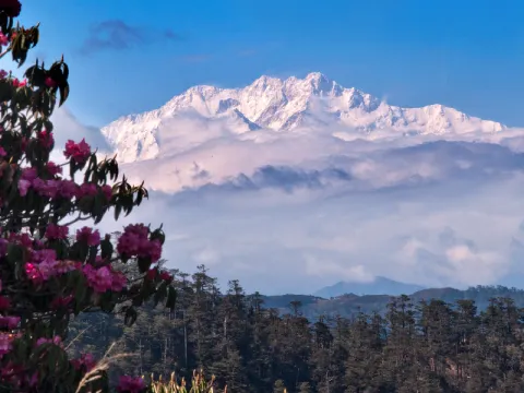
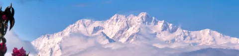
Drifting along the border of India and Nepal, the Singalila Ridge is more than just a trekking route; it is a grandstand view of the world’s roof. This is one of the few places on Earth where you can see four of the five highest peaks in the world (Everest, Kangchenjunga, Lhotse, and Makalu) in a single, sweeping gaze.
While the “Sleeping Buddha” (the profile formed by the Kangchenjunga massif) is the celestial draw, the terrestrial journey is equally enchanting. You’ll walk through misty rhododendron forests, cross international borders casually on foot, and warm yourself by wood-stoves in corrugated-iron teahouses. Whether you trek it or rattle your way up in a vintage 1950s Land Rover, Singalila is the definitive Eastern Himalayan experience.
At 3,636 metres, Sandakphu is not just a viewpoint, it’s the highest point in West Bengal, where the air thins just enough to slow your breath and sharpen your sense of distance. On the clearest mornings, that extra little bit of height is the difference between “nice mountains” and the full, improbable roll-call of giants.
The Route
Stage 1: Manebhanjan to Tumling (11km, 4–5 hours)
The trail starts steeply (punishingly so) on a concrete road. Many hikers skip the first few kilometres by taking a Land Rover to Chitrey, where an old Buddhist monastery awaits. From there, the path meanders through meadows to Meghma (check out the monastery here too) before arriving at Tumling.
Sleep: Shikhar Lodge in Tumling is legendary for its warm hospitality and proximity to the viewpoint.
Note for foreign nationals: Tumling (and some nearby stops on this ridge) sits on Nepal’s side of the border. In recent seasons, foreign nationals trekking from the Indian side have often been restricted from overnighting in Nepal-territory lodges, which can shift your first night to Tonglu (GTA Trekkers’ Hut) or another India-side stay instead. Rules can change, so confirm at Manebhanjan when you register.
Stage 2: Tumling to Kalipokhri (13km, 5–6 hours)
Enter the Singalila National Park properly. You'll dip into Nepal, walk through bamboo glades (prime Red Panda territory), and pass the check post at Gairibas. The day ends at Kalipokhri (Black Lake), a dark, sacred pond surrounded by prayer flags, sometimes glassed over with ice in deep winter, and always atmospheric.
Sleep: Chewang Lodge offers basic rooms and hearty meals.
Stage 3: Kalipokhri to Sandakphu (6km, 3 hours)
A short but steep day. The final 2km ascent to Sandakphu is known as the “Test of Patience.” As you crest the ridge, the wind picks up, and suddenly, the entire Himalayan range reveals itself.
Sleep: Sherpa Chalet is the place to be. The rooms are drafty, but the common room is lively, and the views from the deck are unbeatable.
Stage 4: The Ridge Walk (Sandakphu to Phalut) (21km, 7–8 hours)
This is the crown jewel of the trek. The trail stays mostly flat, traversing the high ridge with Everest on your left and the valleys of Bengal on your right. The vegetation turns alpine, with dwarf rhododendrons and silver firs. Phalut is windier, wilder, and feels closer to Kangchenjunga than Sandakphu.
Sleep: GTA Trekkers’ Hut or private lodges. Facilities here are very basic (often bucket toilets and limited electricity).
Stage 5: The Descent (Phalut to Gorkhey) (15km, 4–5 hours)
Drop down through bamboo forests into the gorgeous valley of Gorkhey. With its cornfields and the meandering Gorkhey Khola stream, it looks like a scene from a storybook. It’s the perfect place to soak your tired feet in the river.
Next Steps: From Gorkhey, trek to Srikhola (another lovely riverside hamlet) and catch a shared jeep back to Darjeeling or NJP.