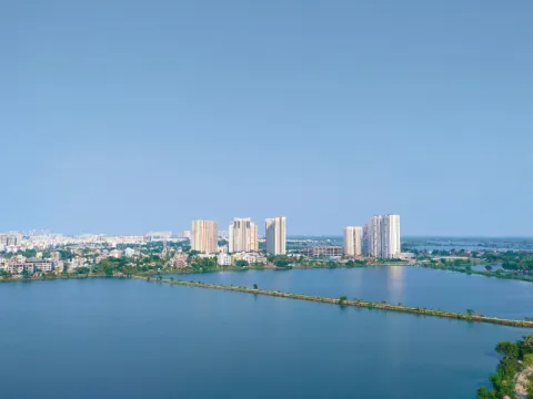
The wetlands cover roughly 12,500 hectares to the east and southeast of the city, an area equivalent to the older Kolkata clusters combined. Kolkata calls them, with more precision than affection, the kidneys of the city. From the air they’re a patchwork of rectangular water bodies (bheries) divided by earthen embankments; from ground level, flat water under an enormous sky, the city’s edge a thin line on the horizon.
What this landscape does, continuously, for roughly a century, is one of the most remarkable feats of applied ecological engineering in urban history. The wetlands were formed by the eastward shift of the Bidyadhari river, and Kolkata’s land slopes east, which is why the British cut canals to carry the city’s wastewater this way. Farmers turned that drainage problem into a food economy from around the 1930s.
The system: sewage from a metropolitan region of fourteen million people flows east into the wetlands, where it’s treated not chemically but biologically. Nutrients feed algae and aquatic plants, consumed by herbivorous fish (rohu, katla, tilapia), which are harvested by the communities who own the ponds. The nutrient-depleted water then irrigates vegetable farms on the embankments before draining toward the Sundarbans. The city produces waste, waste produces fish, fish produce food, water produces vegetables, vegetables feed the city: a closed cycle needing no external energy beyond sunlight and labour and no engineered system in the modern sense.
The third element is garbage: Dhapa, Kolkata’s dumping ground, where vegetables are grown on garbage substrate irrigated with effluent. The complex runs to some 300 fishponds, rice paddies, wholesale markets and 43 villages across eleven zones.
Scale: 10,000-15,000 tonnes of fish annually, plus a daily vegetable harvest in the low hundreds of tonnes from Dhapa. It employs an estimated 30,000 directly, with up to 60,000 living across the 43 villages (precise counting is impossible given the informal, multi-generational work). It’s also Kolkata’s primary flood buffer, absorbing monsoon rainfall the drainage system couldn’t otherwise handle, a value made visible wherever wetland has already been lost to development.
On 19 August 2002 the wetlands became Ramsar Site 1208, West Bengal’s first designation, seventeen years ahead of the Sundarbans (2019). The designation recognises this as a working landscape rather than protected wilderness, conserved through the continuation of the traditional practices that created it.
Article Content
Text Body
Is Background Visible
Off
Published on
Article Image
Image
Updated On
Read Time
2
Article Type
Location
Article Videos
Is Background Visible
Off
Upload Video
Content Family
General Purpose
Image Gallery
Upload Images
Is Background Visible
Off
Images View Mode
Simple
Video Gallery
Is Background Visible
Off
Upload Video
gallery view mode
horizontal
action if location
default
Comments